
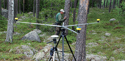
 The Postex and Digitech® Professional caliper with Postax software provide an accurate and efficient solution for mapping individual trees or other objects on a plot. Three distances are ransferred through Bluetooth® or IR to the Digitech computer terminal where the data is recorded, along with any other details on species, diameter, height and more for each tree. For a correct position on each tree center, consideration is taken for the diameter of the particular tree.
The method for individual positioning of trees is perfect when accuracy demands are moderate, as when connecting information on ground measured trees to a laser scanned air measuring operation or to follow up individual trees on sample plots. Great for permanent sample plots, such as with continuous forest inventory (CFI), and when it is critical to revisit the correct tree in a plot. Positioning is still accurate when view of the sighting to the object is obscured by shrubs and branches with ultrasound technology. For an efficient field system solution, run the Postex together with the Digitech Professional caliper and software PosTax. Capture and process all plot data in one place. The Postex system has been developed in cooperation with leading scientists and is based on proven functional and rugged components designed by Haglöf Sweden.